Umbrellas at the Ready: Sydney Faces a Soggy Start to the Work Week
A Damp Start for Sydneysiders
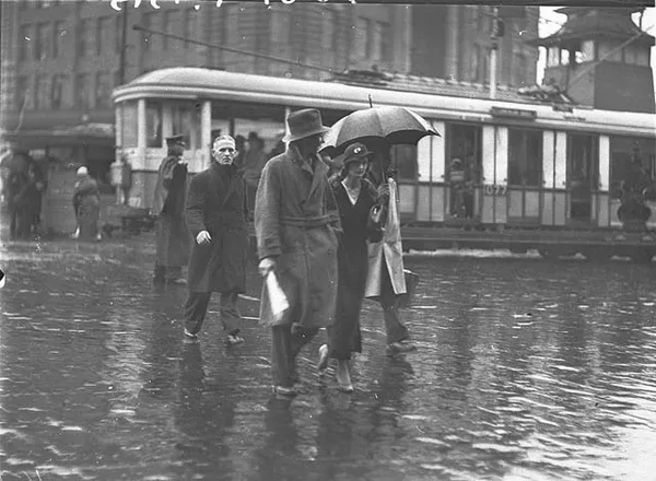
As the new work week begins, residents of Sydney should prepare for a damp and humid Monday. Following a weekend of unsettled weather, a lingering trough over the New South Wales coast continues to influence the city's conditions. Today, Monday, 9 March 2026, is expected to be characterized by intermittent showers and the potential for late-day atmospheric instability. While the intense downpours seen over the weekend have largely moved on, the moisture in the air remains high, ensuring that an umbrella will be an essential accessory for anyone heading outdoors.
Morning: Commuter Caution Advised
The morning hours are likely to see the highest frequency of precipitation across the metropolitan area. Commuters can expect a high chance of showers—peaking at nearly 90% probability—particularly during the early morning and through the midday period. While these showers are expected to be relatively light, with a total predicted rainfall between 1mm and 5mm, the persistent drizzle may lead to slippery conditions on the roads. Motorists are advised to take extra care on major arteries and across the Harbour Bridge, where visibility may be slightly reduced during heavier bursts. Temperatures will start in the low 20s, with high humidity levels near 80% making the air feel thick and sticky from the outset.
Afternoon: Storm Potential and Peak Warmth
As we move into the afternoon, the temperature is forecast to reach a maximum of 26°C. While the sun may attempt to peek through the persistent cloud cover, the primary concern for the later part of the day is the development of isolated thunderstorms. Atmospheric conditions remain conducive to storm activity, which could bring brief but sharp bursts of rain to the western suburbs and the CBD. Wind speeds will remain steady, coming from the south and southeast at 15 to 25 km/h. These coastal breezes will provide some air movement but will also continue to push moisture-rich air inland, maintaining the humid feel throughout the peak of the day.
Evening: Conditions Begin to Ease
By the evening, the weather is expected to stabilize significantly as the coastal trough begins to weaken. The southerly winds that dominated the daytime hours will start to ease, becoming light and variable after sunset. While cloud cover will likely persist through the night, the chance of further rain decreases to approximately 25%. Overnight, the temperature will drop to a minimum of 20°C. This cooling trend, combined with the easing winds, should provide a more comfortable environment for sleeping compared to the previous few nights.
Today's Weather at a Glance
- Maximum Temperature: 26°C
- Minimum Temperature: 20°C
- Rain Probability: 80% to 90%, most likely in the morning and early afternoon.
- Expected Rainfall: 1mm to 5mm.
- Wind: South to southeasterly at 15 to 25 km/h, easing in the evening.
- Storm Risk: Possible thunderstorm development in the late afternoon and evening.

Green Pints, Grand Operas, and Global Art: Celebrating St. Patrick’s Day in Sydney

Sydney’s Green Tuesday: St Paddy’s Spirit, A-League Thrills, and a City in Transition
Sydney Commuter Alert: Bridge Works on James Ruse Drive and Major Victoria Pass Closure