Umbrellas at the Ready: Sydney Braces for a Muggy Tuesday Soak
Unsettled Skies and Rising Humidity: Sydney’s Tuesday Outlook
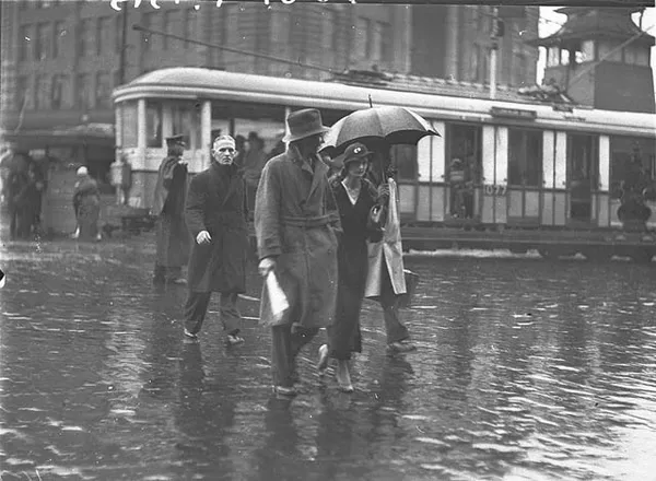
Sydney residents should keep their umbrellas close at hand this Tuesday, March 3, 2026, as a humid and unsettled weather pattern settles over the city. A low-pressure trough currently tracking through the eastern states is expected to bring a combination of high humidity and scattered showers, making for a notably "sticky" day across the metropolitan area. The presence of this trough, interacting with monsoonal flow from the north, has created an unstable environment that will dominate the local conditions for the next twenty-four hours.
Morning: Overcast Starts and Increasing Humidity
The day is expected to begin on a mild and damp note, with temperatures starting between 21°C and 22°C. Throughout the early morning, skies will remain largely overcast, providing little relief from the rising humidity levels, which are projected to sit near 80%. Commuters may encounter patches of light drizzle during the morning peak hour, particularly in the northern and eastern suburbs. While rainfall will be light initially, the thick cloud cover will persist, signaling the shift toward more active weather later in the afternoon.
Afternoon: Peak Heat and Rainfall Potential
As the day progresses, the mercury is forecast to climb to a muggy maximum of 27°C. While this temperature is typical for early March in Sydney, the high moisture content in the air will likely make it feel several degrees warmer, pushing the "feels like" temperature into the low thirties. According to the latest data, the likelihood of showers will increase to approximately 45% as the afternoon heat peaks. There is also a distinct possibility of localized thundershowers, especially in the western suburbs and along the coastal fringe, as the atmospheric instability from the approaching trough intensifies.
Coastal Conditions and Wind Forecast
Wind conditions are expected to remain relatively stable, with gentle north-easterly breezes of approximately 19 km/h persisting through the day. These winds may offer a slight cooling effect for those near the coastline, but inland areas will likely experience the full weight of the humidity. For those visiting the beaches, the sea temperature remains a pleasant 23°C. However, the Bureau of Meteorology notes that despite the heavy cloud cover, the UV index will reach a "Very High" level of 9. Sun protection is strongly recommended for any outdoor activities between 10:00 AM and 4:00 PM.
Evening: A Mild and Cloudy Finish
By evening, conditions are expected to stabilize slightly, with the temperature dropping back to a mild 23°C. While the heaviest showers are predicted to clear by nightfall, the overcast conditions will likely remain, keeping the overnight minimum from dropping significantly. No formal severe weather or flood warnings are currently in place for the Sydney basin, but residents should remain alert for localized heavy falls that can often accompany autumn troughs. Looking ahead, the humidity is expected to linger into Wednesday as the trough continues its eastward track.
Daily Weather Summary
- Maximum Temperature: 27°C
- Minimum Temperature: 21°C
- Rainfall: Showers likely (45% chance)
- Humidity: High (approx. 82%)
- UV Index: 9 (Very High)
- Winds: NE at 19 km/h

Green Pints, Grand Operas, and Global Art: Celebrating St. Patrick’s Day in Sydney

Sydney’s Green Tuesday: St Paddy’s Spirit, A-League Thrills, and a City in Transition
Sydney Commuter Alert: Bridge Works on James Ruse Drive and Major Victoria Pass Closure