Sydney Sizzles: Mid-Autumn Heatwave Pushes Temperatures Toward 30°C
A Warm Outlook for the Harbour City
Sydney residents can expect a notably warm and humid Thursday, March 19, 2026, as the city moves further into the autumn season. While March typically brings milder conditions, today’s forecast indicates a significant departure from long-term averages. According to the latest data from the Bureau of Meteorology and regional forecasting models, Sydney is bracing for temperatures that could reach the 30°C mark, driven by unusual weather patterns across the eastern coast of New South Wales.
Morning: A Muggy Start for Commuters
The day is set to begin with a high level of humidity, hovering around 85% during the early morning hours. Residents waking up will find temperatures already sitting at a mild 21°C to 22°C under a veil of cloud cover. While the risk of precipitation remains relatively low during the morning peak—estimated at roughly 15% to 20%—the air will feel significantly heavier than usual for this time of year. This humidity is partly attributed to the lingering influence of the weakening 2025–26 La Niña, which continues to channel coastal moisture toward the Greater Sydney region.
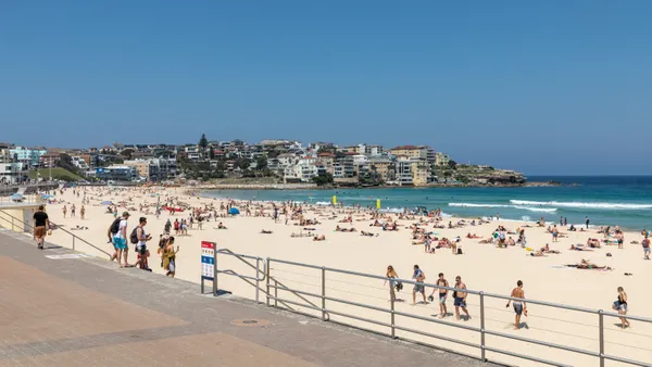
Afternoon: Peak Heat and Sunshine
As the morning cloud cover begins to break, the mercury is expected to climb rapidly. Forecasters predict a midday temperature of 28°C, eventually peaking at a high of 30°C between 2:00 PM and 4:00 PM. This peak is roughly five degrees higher than the typical March maximum for Sydney. The afternoon will also see a shift in conditions, as humidity levels are expected to drop to approximately 22% to 30%, providing a drier heat compared to the morning transit period.
Moderate winds will offer some respite for those near the coast. Expected conditions include:
- Southerly to southeasterly breezes reaching speeds of 18 to 24 km/h.
- Higher gust potentials of up to 35 km/h in exposed coastal areas like Bondi and Manly.
- Clearer skies as the afternoon progresses, though some high-altitude cloud may remain.
Evening: A Slow Cool-Down
The heat will be slow to dissipate as the sun sets. Evening temperatures are forecast to remain around 25°C, only dipping to a low of 23°C late into the night. There is a slightly increased risk of light showers—up to 35%—during the late evening hours, so those with outdoor plans should remain aware of potential damp conditions.
Alerts and Long-Range Context
While no severe weather or thunderstorm warnings have been issued for the Sydney metropolitan area today, the Bureau of Meteorology has highlighted an autumn trend of unusually high temperatures across the state. Sea surface temperatures off the New South Wales coast currently remain up to 3°C above average, which can lead to sudden shifts in moisture levels and enhance the energy of localized rain systems. Residents are encouraged to monitor the latest updates as the season evolves.

Biennale Masterpieces and Mind-Body Wellness: Your Sydney Guide Today

Sydney Morning Briefing: Navigating the Rain, the Rates, and the Road Ahead

Overnight Tunnel Closures and Camden Show Events to Shape Thursday Commute