Southeasterly Swells and Silver Skies: The Sunday Forecast for Sydney
Cooler Conditions as Weakening Trough Moves North
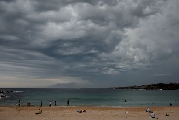
As Sydneysiders prepare for the final day of the weekend, a shift in the local weather pattern is bringing a cooler, more autumnal feel to the city. Sunday, 5 April 2026, will be characterized by persistent cloud cover and a distinct southeasterly flow. A weakening trough currently moving up the New South Wales coast is the primary driver of today's atmospheric activity, while a high-pressure system drifting across Tasmania begins to extend a ridge over the coastal waters.
Morning: A Brisk and Breezy Start
- Temperature: 16°C – 18°C
- Wind: Southeasterly 10 to 15 knots
- Conditions: Mostly cloudy with offshore gusts
Early risers should prepare for a relatively cool start to the day. The defining feature of the early hours will be the wind; southeasterly breezes are expected across the city, though those near the coast should be wary of stronger gusts reaching up to 20 knots. Cloud cover will be significant throughout the morning, providing a silver canopy across the Harbour City and keeping the morning sun largely at bay.
Afternoon: Peak Temperatures and Light Showers
The mercury is forecast to reach a maximum of 20°C during the afternoon. While this remains comfortable for most outdoor activities, a 30% chance of light rainfall suggests that an umbrella would be a wise addition to your Sunday kit. These showers are expected to be brief and scattered, resulting from the coastal trough. Humidity levels will hover around 65%, maintaining a damp but mild atmosphere throughout the midday period as the trough continues its northward progression.
Evening: Winds Ease and Temperatures Dip
As the sun sets, the intensity of the southeasterly winds is forecast to decrease, settling to about 10 knots by late evening. Temperatures will gently decline to a low of around 16°C or 17°C. While the cloud cover may remain heavy into the night, the chance of rain drops to roughly 15% as the high-pressure system begins to stabilize the region. It will be a cool, calm end to the weekend, ideal for indoor relaxation or a late coastal walk.
Coastal and Marine Outlook
For those planning to spend time near the water, official forecasts indicate that seas will range between 1 and 1.5 metres in the morning before decreasing to below 1 metre around midday. An easterly swell of approximately 1 metre will be present, tending southeasterly as the morning progresses. Boaters and swimmers should exercise caution, as wind gusts in squalls can be considerably stronger than the predicted averages, and the southerly swell remains at roughly 1 metre.
Easter Show Thrills and Opera on the Harbour Today
Sydney’s Morning Briefing: Autumn Sun Meets Record-Breaking Fuel Costs

Major Westbound Diversions and Easter Show Congestion: Sydney Traffic Update