Brisk Winds and Hazardous Surf: A Cool Saturday for Sydney
Sydney Settles into a Cool Saturday as Coastal Warnings Remain
Sydney residents can expect a noticeably cooler and crisper start to their weekend this Saturday, 28 March 2026. Following a significant cold front that swept across New South Wales earlier in the week, the city has transitioned into a more autumnal weather pattern. Today's forecast suggests a day of mixed sun and clouds, accompanied by lingering maritime hazards that demand caution for those near the water.
Temperature and Sky Conditions
The mercury is set to stay within a comfortable but cool range today. Morning temperatures will begin around 14°C, making for a brisk start for early risers. As the day progresses, the maximum temperature is expected to reach approximately 21°C. While the sun will make several appearances, the sky will remain partly cloudy throughout the afternoon. By the evening, the air will turn quite cool again, dropping back toward 18°C and eventually hitting an overnight low of 14°C under mostly clear skies.
Morning, Afternoon, and Evening Breakdown
- Morning: A chilly 14°C start with partly cloudy skies. Brisk southerly winds will make it feel slightly cooler than the actual temperature.
- Afternoon: Temperatures will peak at 21°C. Periods of sunshine are expected, though cloud cover will persist at intervals. The chance of rain remains low at approximately 10%.
- Evening: Skies are forecast to clear significantly. The temperature will hover around 18°C to 20°C before midnight, providing a pleasant but fresh atmosphere for evening activities.
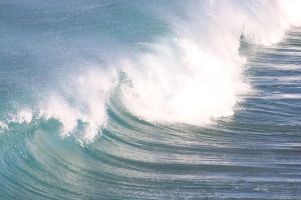
Wind and Hazardous Surf Warnings
While the storm systems from earlier in the week are moving eastward, their influence remains felt along the Sydney coastline. A low-pressure system over the Tasman Sea continues to generate powerful conditions. Authorities have maintained several key alerts for today:
- Hazardous Surf: Large southerly swells are expected to reach heights of 4 to 8 metres. Coastal erosion is a risk, and rock fishing, swimming, or surfing at exposed beaches is strongly discouraged.
- Wind Gusts: While inland winds have begun to ease, exposed coastal areas may still experience strong gusts. Earlier forecasts indicated potential gusts up to 120 km/h in the most vulnerable maritime zones.
- Boating Safety: A wind warning remains in place for Sydney's coastal waters, making conditions dangerous for small craft.
With the rain mostly cleared and the sun peeking through, it is an ideal day for indoor activities or sheltered outdoor walks, provided residents stay well away from the volatile surf zones.
Easter Show Thrills and Opera on the Harbour Today

Sydney’s Morning Briefing: Autumn Sun Meets Record-Breaking Fuel Costs

Major Westbound Diversions and Easter Show Congestion: Sydney Traffic Update